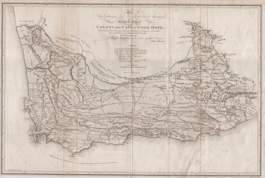
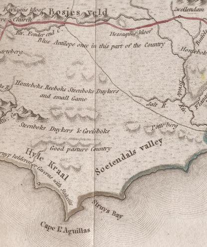

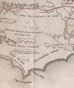
Landmark in the scientific mapping of South Africa. Arguably THE FIRST MAP TO RECORD THE EXTINCTION OF A SPECIES (the Blue Antelope - see illustration #2). The map is uncommonly available other than bound in the 1801 (first) edition of the first volume of John Barrow's Travels in the Interior of South Africa.
Complete title: To His Excellency the Right Honorable the Earl of Macartney This General Chart of the Colony of the Cape of Good Hope, Constructed from bearings, estimation of distances & frequent observations for Latitudes in travelling through the Country in the Years 1797 & 1798 Is Humbly Inscribed, by his obedient & faithful Servant John Barrow.
When Barrow arrived in the colony, as secretary to Lord Macartney, he did not find the most important maps of the colony and he came to the erroneous, but understandable conclusion that the VOC had not produced any significant general maps of the colony. As his 'obedient and faithful servant' Barrow intended to provide answers to Lord Macartney, who had complained that ‘we are shamefully ignorant even of the geography of the country; we have no map that embraces one-tenth part of the Colony; I neither know nor can I learn where this Graaff-Reinet lies- whether it is five hundred or a thousand miles from Cape Town'.
Barrow’s decision to produce an accurate map of the Colony was a laudable response to his not finding maps that satisfied his and Macartney’s needs. They were also disappointed with the flawed maps published by earlier travellers, such as Sparrman and Le Vaillant. On his journeys in the Colony, Barow determined latitude with a sextant about every thirty-five miles and estimated longitude by dead reckoning. The map was engraved by the highly regarded Samuel Neele in London.
Barrow's general map of the Colony of the Cape of Good Hope was a significant advance on prior published maps and is a landmark in the history of mapping of South Africa. His map influenced the maps produced by the Arrowsmiths and other cartographers until 1843 when superior maps were produced by John Arrowsmith and the SDUK (Society for the Diffusion of Useful Knowledge).
The map is replete with annotations on the quality of the land and on wildlife; Barrow records the extinction of the Blue Antelope in the area about today's Bontebok Park, near Swellendam. Despite his good cartography, Barrow concluded after his extensive journies in the region that: "as a mere territorial possession, it is not, in its present state, and probably never could become by any regulations, a colony worthy of the consideration of Great Britain or any other power."
This lot includes 31 pages of text of Barrow's summary on the Interior of South Africa and its mapping (original pages from Volume Two of Barrow's 1804 book); his summary provides the historical context for his map and book.
This quite large (68.5cm x 45.4cm) map is in very good condition. It is uncoloured, as issued. The lines from being folded in the book are still visible. Fold joins have been strengthened from behind with archival tissue paper. There is a 6.5cm repaired diagonal tear, in the blank space off the south coast, that does not extend into terrestrial part of the map. Unlike most examples of this map, there is no unsightly foxing or offsetting.
References:
Norwich's Maps of Africa, Map #228. Not in Tooley's Collectors' Guide to Maps of Africa.
Elri Liebenberg. Unveiling the Geography of the Cape Interior: selected VOC maps of the interior of South Africa. In Elri Liebenberg and Imre Demhardt, eds., History of Cartography. Lecture Notes in Geoinformation and Cartography(Heidelberg: Springer, 2012), pp. 209-32
- Overall Condition: Very good
- Size: 68.5cm x 45.4cm
- Sold By: Roger Stewart Antiquarian
- Contact Person: Dr. Roger Stewart
- Country: South Africa
- Email: [email protected]
- Telephone: +27836541081
- Preferred Payment Methods: LOCAL: EFT; INTERNATIONAL: Bank Transfer; Visa and Mastercard via PayFast
- Trade Associations: IMCOS


