


First edition: folding map (500 x600mm) with canvas backing in beige card covers, foxed and worn on the covers, the map is in good condition.
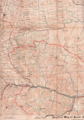
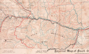
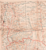
The roads are printed in red, railways in black, rivers in blue, individual farms are named, mounted on linen and not folded.
Shows the De Kaap Goldfields along the Crocodile River.
Compiled for the Field Intelligence Department, Cape Town April 1900. Signed by John Wood and the Director of Military Intelligence Colonel G.F.N. Henderson.
- Overall Condition: A Good Copy
- Size: 8vo (170 x110mm) folded
- Sold By: Clarke's Africana & Rare Books
- Contact Person: Paul Mills
- Country: South Africa
- Email: [email protected]
- Telephone: 021 794 0600
- Preferred Payment Methods: Visa & Mastercard via PayGate secure links and Bank transfers.
- Trade Associations: ABA - ILAB, SABDA


