


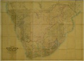
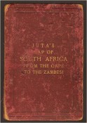
FROM THE CAPE TOTHE ZAMBESI.
Compiled from the best available Colonial and Imperial information.
Including the Official Cape Colony Map by the Surveyor General, Cape Town, Dr. T. Hahn’s Damaraland and F.C. Selous’ Journal & Sketches, Etc.
New and Revised Edition, Published by J.C. Juta & Co., Cape Town, 1889
Map dissected and mounted on linen in panels, 1290 x 1350 mm, coloured, the map is slighty browned but otherwise in good condition, the linen back is stained in places and the name J. Barron is written in ink across one panel, short tears at two folds.
Folds into maroon cloth covers which are very work and insect scarred and the front cover is detached, pin holes at all four corners suggesting the map has been hung on a wall.
- Overall Condition: Fair
- Size: 1290 x 1350 mm
- Sold By: Clarke's Africana & Rare Books
- Contact Person: Paul Mills
- Country: South Africa
- Email: [email protected]
- Telephone: 021 794 0600
- Preferred Payment Methods: Visa & Mastercard via PayGate secure links and Bank transfers.
- Trade Associations: ABA - ILAB, SABDA


