


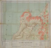
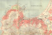
Kaart I, (the first of four sheets of the Peninsula), 770 x 820 mm, folding map of the area of Cape Town from Table Bay to Wynberg, mounted on linen, coloured, slight wear the centre fold, without covers.
Opgemeet 1932 en geteken in die Kantoor van Driehoeksmeting, Mowbray 1933. Gedruk in die Staatsdrukkery, Pretoria, Maart 1934.
- Overall Condition: Good
- Sold By: Clarke's Africana & Rare Books
- Contact Person: Paul Mills
- Country: South Africa
- Email: [email protected]
- Telephone: 021 794 0600
- Preferred Payment Methods: Visa & Mastercard via PayGate secure links and Bank transfers.
- Trade Associations: ABA - ILAB, SABDA


