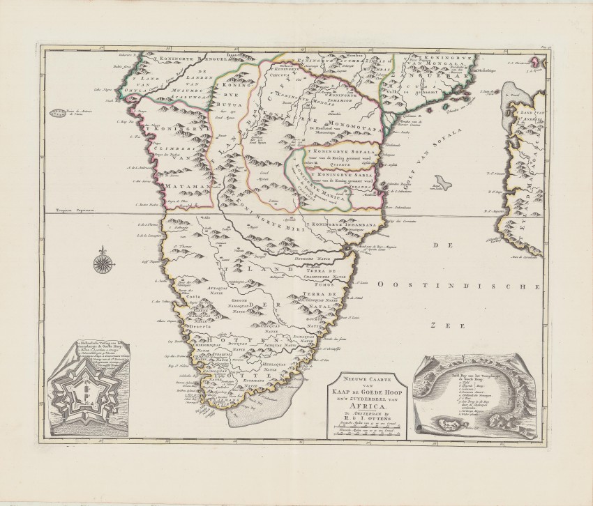
This is a very uncommon map in pristine condition by the famous Ottens brothers. This attractive map is identical to the map, but with Balthazar Lakeman's imprint, that appeared in the posthumous Dutch edition of Peter Kolbe's 1727 book on the Cape of Good Hope Naaukeurige en uitvoerige beschryving van Kaap de Goede Hoop).
The Ottens brothers (Renier and Joshua) commenced their publishing and printing business in 1726, the year that Kolbe died. Kolbe's book first was published in German in 1719 (the Dutch edition of Kolbe's book first was published in 1727 by Balthazar Lakeman, a publisher. Most of the maps in the book were copies of the maps produced for the 1724 - 1726 book on the Cape by Francois Valentyn, published by Van Braam and Onder der Linden.
The map of South Africa in Kolbe's German book was Accurate Vorstellung van Capo Bonae Spei in Afrika - different from the map in the Dutch edition, but both books included insets of The Castle and Table Bay- the insets were very similar. Neither Lakeman nor either of the Ottens brothers was a cartographer.
Who designed the Nieuwe Caarte van Kaap de Goede Hoop an't Zuyderdeel van Africa and which version, Lakeman's or the Ottens brother's, appeared first?
The map displays the little knowledge Europeans had of the interior of South Africa. It displays the location of a number of indigenous peoples and also the borders of indigenous kingdoms. It also shows the western half of Mozambique and names the Gulf of Safala - today's Mozambique Channel.
The map is printed on firm paper, the imprint is dark and the paper is almost unblemished. Uncommon for a map by the Ottens brothers there is only outline colouring of the map.
This map is very seldom in the market, is by the famous Ottens brothers and has an unclear association with the identical map in the Dutch edition of Peter Kolbe's book. A wonderful addition to any collection of maps of South Africa.
Reference: Norwich's Maps of Africa #163
- Overall Condition: Fine
- Size: 56cm x 44cm
- Sold By: Roger Stewart Antiquarian
- Contact Person: Dr. Roger Stewart
- Country: South Africa
- Email: [email protected]
- Telephone: +27836541081
- Preferred Payment Methods: LOCAL: EFT; INTERNATIONAL: Bank Transfer; Visa and Mastercard via PayFast
- Trade Associations: IMCOS


