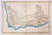
This small map engraved by Chamouin and drawn by Giraldon Bovinet and engraved by Jean Baptiste Chamouin; it has original outline colour and an attractive cartouche and vignette . The map was included in the 1812 Atlas Complet Du Precis De La Geographie Universelle De M. Malte-Brun.
The course and origin of the Nile reflect understanding of the time. The Northern section of Lake Marawui (Malawi) is left opon as it was thought to extend further north but Livingstone had not yeat explored that lake. The interior of the continent is not filled with mythical places and reflects the lack of knowledge of the time. The map also shows a postulated central mountain chain that was thought to run north-south. The map is one of the few to capture a short-lived name of Reunion Island to the west of Madagascar: it was Ile. Bonaparte between 1801 and 1810 and ten reverted to Ile Bourbon.
At the Cape of Good Hope the magisterial town of Zwellendam reflects the eastward expansion of the colony, the border of that time correctly is shown to extend to the Great Fish River and the unnamed Van Plettenberg’s Beacon in the north-west. The coastal outline of the colony is much improved in comparison with 18th century maps in that Algoa Bay is shown to be at a similar latitude as Table Bay (as shown by John Barrow in 1801). This map also excludes the mythical St Helene Nouvelle which appeared on numerous earlier French maps.
The map is in very good condition - the page outside the plate line has been significantly aged toned due to contact with non archival framing materials; nevertheless, the area within the map border is only moderately age toned.
Norwich #116; also Rumsey Collection: http://goo.gl/8q6LYQ
- Overall Condition: Very good
- Size: 30 x 22 cm
- Sold By: Thorolds Legal & Antiquarian Booksellers
- Contact Person: Kim Roberts
- Country: South Africa
- Email: [email protected]
- Telephone: 0118759991
- Preferred Payment Methods: Cash; EFT; Credit Card
- Trade Associations: Antiquarian Bookseller's Association

Similar lots in the current auction View all
Click on an item to view more details and to bid.