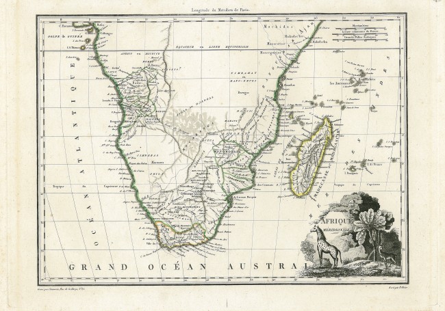
This attractive map was printed from a copperplate and published in 1812 in Paris in the second, improved edition of Atlas complet du précis de la géographie universelle de M. Malte-Brun. The map correctly should be attributed to Conrad Malte-Brun (August 12, 1755–December 14, 1826, who was an important Danish / French cartographer and revolutionary who produced numerous geography texts including Atlas complet. Nevertheless, the map usually is misattributed to Pierre M. Lapie (fl. 1779 - 1850), a French cartographer and engraver, who provided the text, not the maps for the first two editions of Atlas complet. The engravers were Jean-Baptiste-Marie Chamouin (map and the vignette); Guillaume Pellicier (text).
An unusual feature of this map is the name words “Madecasse ou (or) Madagascar” (the former was excluded from the fist, 1809, edition of the map; today Madécasse has disappeared from us but is remembered in the brand of chocolate made in Madagascar. Marco Polo named the island Madageiscar and Diogo Dias, a Portuguese explorer, named it São Lourenço after discovering the island on the day of the Saint.
Another unusual feature of the map is the set of distance scales: the obsolete myriameter (10 000m) established in 1795 with original metric system of the French System of International Units (the only remaining use if in the Scandinavian mil; the French league and Arabic mile.
The route is shown of Portuguese explorers from Luanda towards the hoped for riches in Monomotapa and identifies the famous Pedras Nigras (large monolithic Black Rocks) where the Portuguese has established a fort in 1617.A number of indigenous tribes are identified, including the “Kara Hottentots”, the Cora nation, which no longer exists as an ethnic or cultural entity but has been subsumed into the Griquas.
The map is a valuable addition to any collection because of its uncommon features; it is also scarce (only one prior sale recorded in the past 34 years according to the Antique Map Price record).
RV Tooley. Map Collectors’ Circle N0. 61 (#181 and Plate XV); David Rumsey Collection 2List # 631.071
- Overall Condition: Fine
- Size: 32 x 24 cm
- Sold By: Thorolds Legal & Antiquarian Booksellers
- Contact Person: Kim Roberts
- Country: South Africa
- Email: [email protected]
- Telephone: 0118759991
- Preferred Payment Methods: Cash; EFT; Credit Card
- Trade Associations: Antiquarian Bookseller's Association

Similar lots in the current auction View all
Click on an item to view more details and to bid.