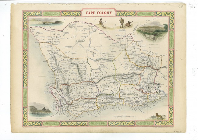

This attractive map of the Cape Colony appeared in the Illustrated Atlas and Modern History of the World, Geographical, Political, Commercial and Statistics, published by J & F Tallis & Co in 1851, in order to coincide with the Great Exhibition. The atlas was highly regarded for its geographic, cartographic and aesthetic qualities. John Tallis formed a partnership with Ephraim Brain, but Tallis lost control when the partnership was incorporated (1854) as the London Printing and Publishing Company (LPPC). The company continued to produce the maps, at least two other editions of the map of the Cape Colony: one with the vignettes and an engraved coin positioned above the Cape Town vignette (there is a variant, with the name of the publisher, below the neatline, omitted) and one without vignettes or coin.
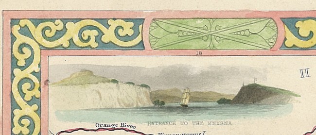
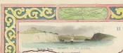
Robert Montgomery Martin, the editor of the atlas, was an author and civil servant who visited the Cape Colony in 1823. Although this map usually is attributed to John Tallis (1815/6 – 1876), he was a publisher and not a cartographer. The map was designed, drawn and engraved on a steel plate by John Rapkin (1813-1899); Henry Warren drew and Henry Bond engraved the attractive, coloured vignettes of Knysna, Klaarwater (Griqua Town, a mission station), Graham’s Town (a border outpost), Cape Town and a lion. The vignette of Cape town shows a flag pole atop Signal Hill – two years later this was replaced by a time-ball – the falling of the ball was triggered by telegraph at 1pm Cape Time by the Royal Observatory; the falling of the ball enabled ships’ navigators to set their chronometers used for determining longitude. The vignette of Knysna, with a sailing ship negotiating the Heads, reminds us that it was an active port at the time.
A seldom-appreciated and historically important feature of this beautiful map is its depiction of the main wagon routes to the north, east and north-east and key outspans along the routes, visited by notable travellers such as John Campbell and William Burchell.
Tooley p. 115 (Tooley probably had not seen the editions by the London Printing & Publishing Company); David Rumsey Collection; Tooley’s Dictionary of Map Makers (Q-Z), pp. 244-5.
- Overall Condition: Fine
- Size: 32 X 24 cm
- Sold By: Thorolds Legal & Antiquarian Booksellers
- Contact Person: Kim Roberts
- Country: South Africa
- Email: [email protected]
- Telephone: 0118759991
- Preferred Payment Methods: Cash; EFT; Credit Card
- Trade Associations: Antiquarian Bookseller's Association

Similar lots in the current auction View all
Click on an item to view more details and to bid.