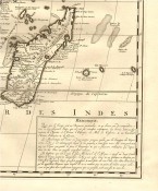
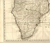
Dressée sur les Mémoires les plus exacts et les observations les plus Nouvelles.
410 x 525 mm, uncoloured, good plate mark and full margins.
(Amsterdam, Gueudeville, 1719)
'A map of southern Africa issued in vol. 6 of the Atlas Historique and Méthodique which was published in seven volumes, compiled by Gueudeville and Garillon, with a supplement by H.P. Limiers and maps by Henri Abraham Chatelain,engraver and geographer of Amsterdam. It was first published in 1705 – 1720 with a second edition in 1732. It contains 300 fine engraved plates, many of them large folding. The maps are largely based on L’Isle. There are many views of Africa and especially of the Cape. In the lower right-hand corner of this map there is a long note describing the Congo, Monomotapa and Kaffraria.' Norwich: Maps of Africa, 1983, Map 165.
- Sold By: Clarke's Africana & Rare Books
- Contact Person: Paul Mills
- Country: South Africa
- Email: [email protected]
- Telephone: 021 794 0600
- Preferred Payment Methods: Visa & Mastercard via PayGate secure links and Bank transfers.
- Trade Associations: ABA - ILAB, SABDA
Similar lots in the current auction View all
Click on an item to view more details and to bid.