History & Information
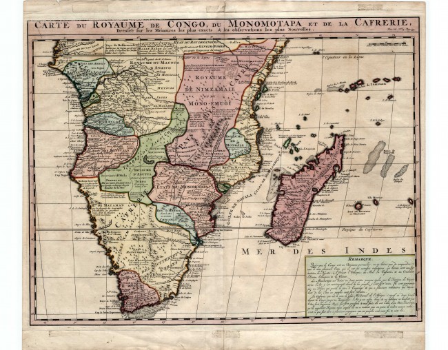
This 1719 map by Chatelain is based on De Lisle's iconic 1700 map that foresook the Ptolemaic tradition. It was published in the massive, multi-volume Atlas Historique et Méthodique, published in Amsterdam. The text box at the lower right contains a note of the Congo, Monomotapa and Kaffraria. The finely engrave map depicts European understanding at the time of Africa. Following de Lisle's lead, Chatelain also discarded Lakes Zachaf and Zaflan. Despite publication in Amsterdam the numerous annotations are in French. The map reminds us of the era of European settlements, some successful some not, along the African coast, e.g. the Dutch settlement at Table Bay is described as Fort Hollandaise, the Portuguese harbour Fort at Sofala in Mozambique is also shown as is the location of the ruins of the French Fort Dauphin in SE Mozambique; Isle de Bourbon (i.e. Mauritius) is shown to have three settlements (St. Paul probably refers to the mission station at today's Port Louis).
Condition: The late colouring is attractive and the two pages that comprise the map have been joined on the verso. Some framing tape marks are visible outside the plate line. Generally a good imprint on firm paper, although there is some neatline fading at the top left.
References: Tooley pp. 36 & 68; Norwich map #165.
Summary: This is an attractively coloured Dutch version of de Lisle's iconic 1700 map of Southern Africa that was the turning point from myth and legend to science (described in the title as 'les observations les plus Nouvelles') .
- Overall Condition: Good
- Size: 52cm x 39cm
- Sold By: Thorolds Legal & Antiquarian Booksellers
- Contact Person: Kim Roberts
- Country: South Africa
- Email: [email protected]
- Telephone: 0118759991
- Preferred Payment Methods: Cash; EFT; Credit Card
- Trade Associations: Antiquarian Bookseller's Association

Similar lots in the current auction View all
Click on an item to view more details and to bid.


