History and Information
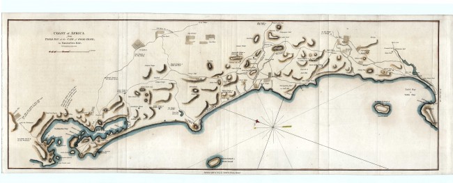
John Barrow travelled extensively in South Africa in 1797 & 1798. His General Chart of the Colony of the Cape of Good Hope was published in 1801 the first volume of his book: Account of Travels into the Interior of Southern Africa. The book's maps It introduced a new standard or printed maps of the region. In the second volume of the book, published in 1804, he included maps of parts of the Colony, e.g. the Cape Peninsula, False, Bay, Knysna and, inter alia, this map of a strip of the Cape west coastal . Although it is not acknowledged, this map draws heavily on a VOC manuscript map by Johan Frederici (Caart van de westelijke kust van Afrika ... 1778; Dutch National Archives 4.Topo.15.15).
This is attractively outline-coloured, engraved map. The map id of historical interest and importance. It displays the wagon roads of the time to Saldanha Bay, the sources of water, the farms (some now well known) and numerous farmers names. The annotation to the north (left) of Saldanha Bay explains that Witte Klip (a large granite outcrop) is a 'fine spring of water that might be conveyed in pipes to Hoetjies Bay'. Some time later, local farmers would argue about water right, the village became known as Twisfontein (dispute spring) and then, on resolution of the dispute, Vredenburg (town of peace) Condition: this map is in exceptionally good condition; there is no offsetting, the map is clean and it has been de-acidified. There imprint is crisp and does justice to Samuel Neele, the engraver.
References: Norwich #228; not in Tooley; http://libweb5.princeton.edu/visual_materials/maps/websites/africa/barrow/barrow.html
Summary: This attractive map was produced for one of the famous pioneer travellers in the cape, who also made a significant contribution to the mapping of the region. It surely will be admired and valued by anyone with an interest in the history of the Cape West Coast. It featured recently in an exhibition held at Princeton University.
- Overall Condition: Fine
- Size: 69.5cm x 24.3cm
- Sold By: Thorolds Legal & Antiquarian Booksellers
- Contact Person: Kim Roberts
- Country: South Africa
- Email: [email protected]
- Telephone: 0118759991
- Preferred Payment Methods: Cash; EFT; Credit Card
- Trade Associations: Antiquarian Bookseller's Association


