


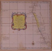

This map covers the southwestern coastline from the Kingdom of Benguela to the Cape of Good Hope. It was prepared for the Minister of the Navy, Count of Maurepas, and is nicely detailed with locations of settlements, anchorages, and forts and is hand-coloured. The map has been laid down onto backing 400 x 385 mm, and has a mask. There are one or two light spots of discolouration, otherwise in good condition
- Jacket Condition: n/a
- Binding Condition: n/a
- Overall Condition: good
- Size: 260 x 270 mm
- Sold By: Africana Books
- Contact Person: Stefan Blank
- Country: South Africa
- Email: [email protected]
- Telephone: 021 4475741
- Preferred Payment Methods: Direct deposit/EFT to our account, or Visa, Master & Amex cards - but an extra 5% will be debited for card chgs.. Paypal also welcome, but 7% charge will be levied, as there are PP &repatriation fees to be paid.
- Trade Associations: Member of SABDA


