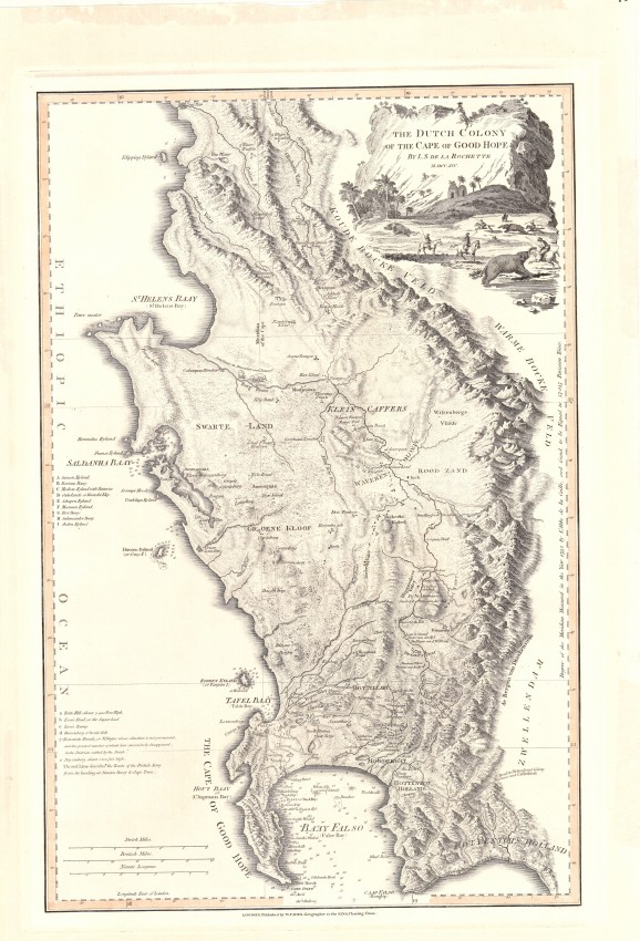
This is one of the most fascinating maps of the Cape of Good Hope published in the same year that the English captured the Cape after the battle of Muizenberg. It is a sought-after, historically important, attractive and highly desirable milestone in the history of the Cape and its cartography.
Louis Stanislas De la Rochette (who later adopted his wife's surname, D'Arcy, to his first names) compiled his map in 1782, when it first was published with the same title. He used a number of primary sources, some up-to-date and some that were almost a century old, albeit historically important; the map met the English need for a more accurate map of the territory in which it had become increasingly interested.
In August 1795 the English captured the Cape from the Dutch VOC after the Battle of Muizenberg. In the same year, this new edition of the map was published with numerous name changes. In their haste to publish the new edition before the end of the year, De la Rochette and William Faden, a leading English cartographer and publisher, forgot to change the title of the map from Dutch Colony to The English Colony of the Cape of Good Hope. On some copies of this 1795 new edition the route marched by the victorious military force was drawn in red by hand – on this example the route is engraved and there is no manuscript colouring of the route.
The map is even more fascinating because it is a cartographic version of an historical novel. The map includes some of the places visited by Simon van der Stel’s party in their journey into Namaqualand a century earlier. It features the names of some of the first settlers in the area between Table Bay and the Hottentots Holland Mountains (ca. 1675 – 1705). It shows the network of wagon roads in the colony in the 18th century; the routes of a number of these roads are still followed by modern arterial roads.
The map also names places that were prominent in the first scientific land survey, undertaken in 1752 by the French astronomer, Nicolas Louis De la Caille; e.g. Vygekaraal, Contreberg near today’s Darling and the mountain, Riebeeks Kasteel; De la Rochete also shows de la Caille’s terrestrial meridian and, along the right axis, gives its length, across a degree of latitude – an unusual record. Saldanha Bay and the coastline to St. Helena Bay were copied from De la Caille and famous French Hydrographer d’Après de Mannevillette ... and were not accurate.
This map was published again in 1825 and 1838 but James Wylde, and then his son, the new owner of the publishing business did not keep up to date with changes in the rapidly expanding colony - they did, however, remove reference to Dutch occupation of the Cape! A German edition of this popular map was published by Schrämbl in 1789. As more up to date maps were published, De la Rochette’s attractive and once popular and important map last was published in 1838 and was of historical interest only.
The map has been professionally conserved by cleaning and de-acidification. It remains a strikingly attractive, historically important map of the Cape of Good Hope.
Tooley p. 40, pl. 30
- Overall Condition: Very good
- Size: 32.5cm x 50.0cm
- Sold By: Thorolds Legal & Antiquarian Booksellers
- Contact Person: Kim Roberts
- Country: South Africa
- Email: [email protected]
- Telephone: 0118759991
- Preferred Payment Methods: Cash; EFT; Credit Card
- Trade Associations: Antiquarian Bookseller's Association

Similar lots in the current auction View all
Click on an item to view more details and to bid.