


Full colour map mounted on linen and folded ( 860 x110mm), a very good copy.
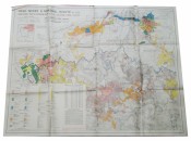
Topocadastral map showing gold mining company holdings in the areas of Krugersdorp, Roodepoort, Johannesburg, Benoni, Springs, Nigel Heidelburg, Vereeniging, Potchefstroom, Klerksdrop, Vredefort, Heidelberg, Heilbron, Frankfort, Lindley, Kroonstad, Ventersburg and Bothaville.
The map includes national roads, main roads and secondary roads, railways, rivers, towns and townships, mine boundaries and outcrop and sub-outcrop. Two data insets: Key to mines and holdings. Summary of output for major producing mines December 1945 – November 1946.
Chiefly in colour. Scale 1 : 250,000
Published under Government Printer Copyright Authority 659 of 19/11/1946.
- Overall Condition: A Very Good Copy
- Sold By: Clarke's Africana & Rare Books
- Contact Person: Paul Mills
- Country: South Africa
- Email: [email protected]
- Telephone: 021 794 0600
- Preferred Payment Methods: Visa & Mastercard via PayGate secure links and Bank transfers.
- Trade Associations: ABA - ILAB, SABDA


