
This is a beautiful, full colour, chromolithgraph of southern Africa printed in the last year of the first Anglo-Boer War. The map is crammed with detail of great historical geography interest: it is a conversation piece, e.g. an alterntive name for Mossel Bay (1848) is inserted: Aliwal South (to differentiate it from Aliwal North), named after a battle in India where Harry Smith, the Cape Governor, has won a victory ... needless to say the locals did not appreciate the new name and it soon fell into disuse).
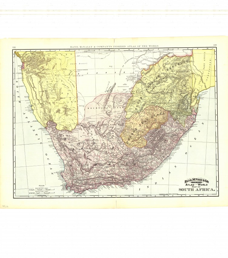
This map is a fine, 1892 production for the Indexed Atlas of the World by the famous Rand McNally Company. The map is of Africa south of 22 degrees south. In the west, tody's Luderitz in Angra Penguena and Shark Island, later notorious for the genocide of Hereros and Namaquas, is identified. The Cape Colony, Orange Free State and South African republic are colour coded as are what became the German (South) West Africa and Mozambique. Griqualand and Zuluand are incorporated in the Cape Colony and Vrijheid in the SAR.
Apart from the political geography the map also shows the development of the railway network that started out in 1875 from Cape Town and then from Port Elizabeth and East London toward the diamond fields. With discovery of gold in the Witwatersrand in 1886, the railway swung north towards the gold fields about Johannesburg; the boer-controlled SA Republic built its railway line to Delagia bay in order not to be reliant on the British controlled Cape Colony. The railway network was to influence the distribution of the second Anglo Boer War.
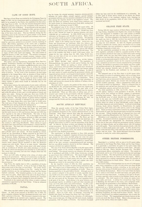
The verso of the map is a page of text on the history and political and developmental geography of South Africa as understood in 1892 from a colonial perspective - it is fascinating reading (and an image has been provided).
The map has had some small tears at the margins that have been professionally repaired and which do not detract from the aesthetic appeal of this beautiful and really interesting cartographic snapshot of Southern Africa at the end of a conflict that was to be repeated (in the Second Anglo Boer War).
- Overall Condition: Very good
- Size: 67.0cm x 50.0cm
- Sold By: Thorolds Legal & Antiquarian Booksellers
- Contact Person: Kim Roberts
- Country: South Africa
- Email: [email protected]
- Telephone: 0118759991
- Preferred Payment Methods: Cash; EFT; Credit Card
- Trade Associations: Antiquarian Bookseller's Association

Similar lots in the current auction View all
Click on an item to view more details and to bid.