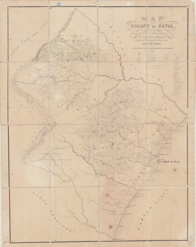
This item of Nataliana is very seldom in the market: the first accurate map of the Colony of Natal; and that shows early land distributions to settlers.
Not much is known about Watts. According to the S2A3 Biographical Database of Southern African Science: "J. Alfred Watts was employed in the Surveyor-General's office of Natal Colony in the eighteen-fifties. He compiled the first reasonably accurate map of Natal in 1855, on a scale of six miles to the inch (1:380 160). It showed rivers, roads, settlements, missions, farms (including their size and the names of their owners), and the areas occupied by African chiefs and their people; it was based mainly on the surveys that had been carried out by the Surveyor-General and his staff during the previous ten years. The map is now in the Local History Museum, Durban.Watts was declared insolvent in 1863. At the time of his death in 1874 he resided in the Orange Free State (now the Free State)."
The map was published in 1855 and again in 1857. This example is the first edition, which was dissected and laid on linen. The map was obviously much used: it has holes in each corner from being hung up in some office or police station - we have not repaired this legacy from practical use. The paper is age-tone but the map itself is in good condition. There are a few small stains in the bottom central panel of the map that do not interfere with reading it.
The map is CO 700/NATAL8 in the British national Archives; it not mentioned by either Tooley of Norwich.
This is a scarce historical map of the Colony of Natal that obviously was much used - a must for any serious collector of documents from nineteenth century Natal.
- Overall Condition: Very good
- Size: 67cm x 90cm
- Sold By: Thorolds Legal & Antiquarian Booksellers
- Contact Person: Kim Roberts
- Country: South Africa
- Email: [email protected]
- Telephone: 0118759991
- Preferred Payment Methods: Cash; EFT; Credit Card
- Trade Associations: Antiquarian Bookseller's Association


