


Author: De Fer Nicolas (1646-1720)
Atlas: L’Atlas curieux ou le monde represente dans des cartesgenerales et particulieres, Paris Date: 1705
Sheet size: 28x40,5cm (11x15.9 inches)
Plate area: 23x32,5 cm (9.1x12.8 inches)
Overall conditions: Very good conditions. Occasional foxings
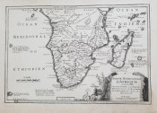
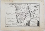
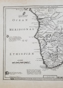
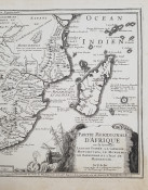
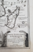
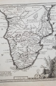
Copper map of South Africa of 1705 by Nicolas De Fer (1646-1720). The map features also modern-day Angola, Maui, Zimbabwe, Tanzania, Mozambique, Namibia, Botswana, Madagascar. Beautiful cartouche in the lower right corner featuring a sea monster and a shipwreck.
Shipping cost to South Africa: slow tracked shipping with NL Post: $ 12.5
Shipping cost to USA: slow tracked shipping with NL Post: $ 10
Shipping cost to Europe: slow tracked shipping with NL Post: $ 10.5
Other destinations: Please ask! We always combine shipping
- Overall Condition: Very good conditions
- Size: 11x15.9 inches
- Sold By: Sephora Libri
- Contact Person: Elena Serru
- Country: Italy
- Email: [email protected]
- Telephone: 3492903979
- Preferred Payment Methods: paypal credit card
- Trade Associations: Sephora di Elena Serru


