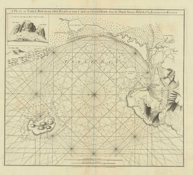
This is the first publication, in 1778, of the very scarce English sea chart and plan of Cape Town and environs, drawn from Van Keulen’s 1728 information. (Van Keulen published the map in 1753 in de Marre, J.; van Keulen, J. (1753). De Nieuwe Groote Lichtende Zee-Fakkel.)
Although this edition of the maritime map is a scarce cartographic anachronism, it provides very important historical detail, from the 1720s of the developing Cape Town, a time when the Dutch colony has expanded beyond the Liesbeeck River and when the VOC kept secret their sea charts and maps of the colony. The Plan of Table Bay is both a practical sea chart of Table Bay, which shows ‘the road’ for maritime navigation in Table bay, and a plan of the terrestrial layout of the small town below Table mountain; its coastal fortifications; the ‘Company’s Garden’ (the United Dutch East India - VOC); and the rivers that flowed from copious springs at the foot of the Table Mountain complex the sites of the infamous public Gallows; early farms on the outskirts of the village; and the main wagon roads to the developing colony rural districts.
The ‘New Battery’ on the western shore of the bay is the Chavonnes Battery, erected in the period 1717 to 1726; the ‘Cape Windmill’ in the south-east is the Oude Molen (Old Mill) that was established in 1717 and demolished in the twentieth century; it was the first windmill in South Africa. The nearby Water Mill was the Papenboom Mill, ’about one and a half hours distant from the Castle’ (Fort of Good Hope on the map), established towards the end of the 17th century to supply the local brewing industry; the copious springs below the eastern face of Table Mountain still supply a brewery (and the public) in the suburb of Newlands.
This is a scarce sea chart of Table Bay and a plan of the surrounding land is an under-appreciated landmark map of the Cape of Good Hope: it provides an important cartographic record of the region in the 1720s. The Antique Map Price Record records only one sales of this first edition of the map in the past thirty years.
This map: Tooley p 63 (Plate 47); Norwich #269.
Van Keulen’s map: http://www.atlasofmutualheritage.nl/nl/Kaart-Tafelbaai.2530 and http://www.vliz.be/nl/imis?module=ref&refid=63034
- Overall Condition: Very Good; some fine creases
- Size: 54.1 x 48.0cm
- Sold By: Thorolds Legal & Antiquarian Booksellers
- Contact Person: Kim Roberts
- Country: South Africa
- Email: [email protected]
- Telephone: 0118759991
- Preferred Payment Methods: Cash; EFT; Credit Card
- Trade Associations: Antiquarian Bookseller's Association

Similar lots in the current auction View all
Click on an item to view more details and to bid.