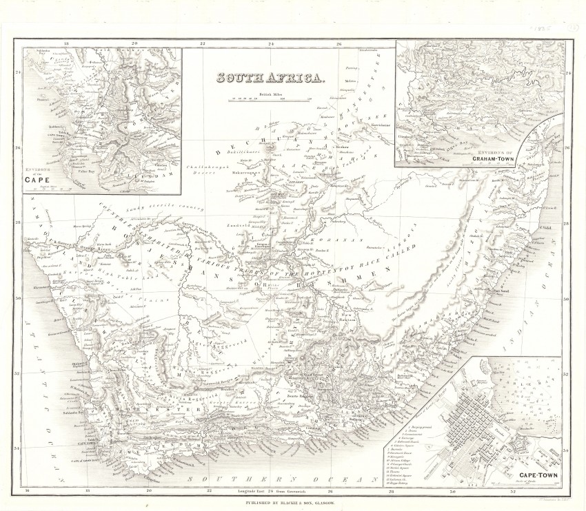
This is a well executed 19th century map of South Africa with historically important insets of Cape Town, the Environs of Grahamstown and the Environs of the Cape - considerable detail in tiny insets all based on the latest information avabale to the Colonial Office in London.
Blackie and Son was a well known Scottish publisher and Jonathan Jonhston had engraved for the Bartholomew family in Edinburgh. This map is a very uncommon version of the well-known 1834 map of the SDUK map of (Society for the Diffusion of Useful Knowledge); the geography of the map was arguably the best at that time.
The inset of Cape Town was the first English plan of this city to appear in an atlas (Schrire in Map Collectors’ Series No17;Plate XIII, map 38) and is of great historical interest. However, the publisher decided not to include the inset of George, which is on the SDUK map; that inset is replaced by the title and distance scale. The inset of the Environs of the Cape is of interest for the passes it shows: the unnamed Sir Lowry's Pass and the unnamed adjacent Gantouw Pass; the forgotten Donkerhoek Pass to the north of the Riviersonderend and at Du Toit became the hard road from Villiersdorp to Genadendal - describe by Charles Michell as an 'execrable road'; it also shows the terrifying Witsenberg Pass between Tublach and the Ceres Valley.
The Environs of Grahamstown is important for its accurate depiction of the Eastern Cape border country and its wagon routes.
A conundrum of this map is that Blackie and Son cooperated for man years before Blackie & Son was established in 1891. The map was folded and probably illustrated a book which has yet to be identified.
The map has been cleaned and de-acidified and the page reversibly laid on acid free Japanese rice paper in order to stabilise the page.
This variant of the SDUK map is not mentioned in Tooley or Norwich. The cartobibliography of the SDUK map, of which this map is a close copy, is described here.
- Overall Condition: Very good
- Size: 37 cm x 31cm
- Sold By: Thorolds Legal & Antiquarian Booksellers
- Contact Person: Kim Roberts
- Country: South Africa
- Email: [email protected]
- Telephone: 0118759991
- Preferred Payment Methods: Cash; EFT; Credit Card
- Trade Associations: Antiquarian Bookseller's Association

Similar lots in the current auction View all
Click on an item to view more details and to bid.