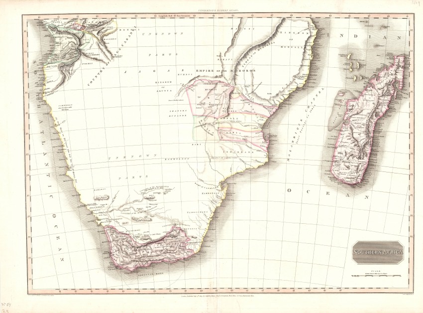
This is the Southern Africa detail, in original colour, of John Pinkerton's map of Africa published in his Modern Atlas. Such was the quality of the maps in Pinkerton's Atlas that David Rumsey has rated the atlas as one of the best of its time.
The hand-coloured map comprises two sheets that have been joined.The highly regarded L. Hebert Snr., from the Colonial Office, worked with Pinkerton in designing the map – confirmation of Pinkerton’s attention to the latest information. It was engraved by the highly regarded SJ Neele. There are vast tracts of 'unknown parts' , as is to be expected of the candid Pinkerton. Although Lake Maravi (Malawi) is shown, Livingstone discovered its extent only half a century later - its shape and position was taken from reports by Portuguese explorers. The Cape Colony section of the map draws on John Barrow's map published a few years earlier. The Klaboliggme Well is The Eye of Kuruman which had been 'discovered' in the 1801 expedition of Somerville & Truter, the later being Barrow's father-in-law inter alia.
John Pinkerton (1758-1826) was one of the leading Scottish cartographers who abandoned the elaborate decorations of the previous century and focused on accurate information from Africa.The map was engraved in 1814 by the well-known Samuel Neele. This map is from A modern atlas, from the latest and best authorities, exhibiting the various divisions of the world, with its chief empires, kingdoms and states, in sixty maps, carefully reduced from the largest and most authentic sources. Directed and superintended by John Pinkerton, author of Modern geography, &c. London: T. Cadell and W. Davies, Strand; and Longman, Hurst, Rees, Orme, And Brown, Paternoster Row. 1815.
The map is printed on heavy paper; a marginal tear that does not extend into the map has been professionally repaired. The map is in fine condition.
References: Norwich mp #186 (American edition); not in Tooley
- Overall Condition: Fine
- Size: 69cm x 50cm
- Sold By: Thorolds Legal & Antiquarian Booksellers
- Contact Person: Kim Roberts
- Country: South Africa
- Email: [email protected]
- Telephone: 0118759991
- Preferred Payment Methods: Cash; EFT; Credit Card
- Trade Associations: Antiquarian Bookseller's Association


