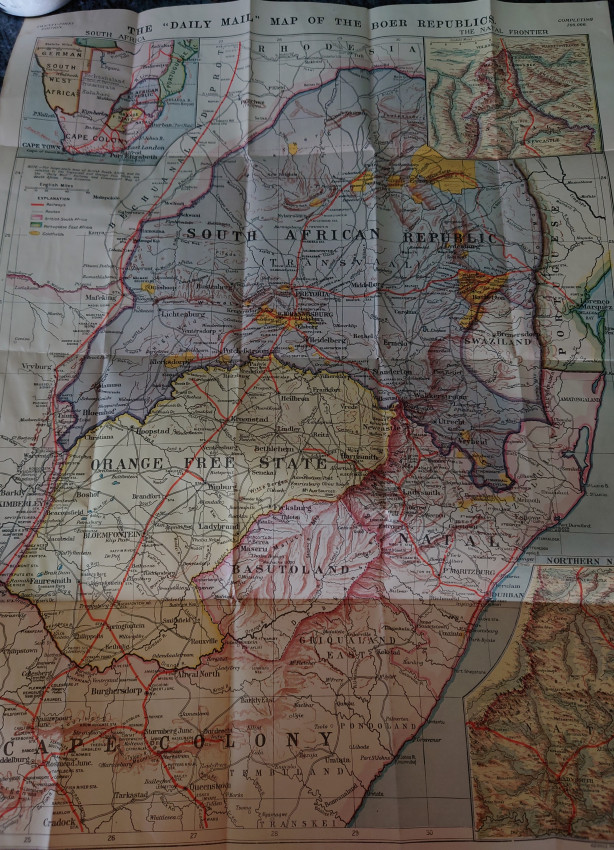
London, George Philip & Son,1899. Engraved map with original colour in full-wash, with three inset maps, folding. 05 by 560mm. (27.75 by 22 inches). Front panel is fragile and loose with loss to the edges. Rear panel intact.
This map, produced and published by the Daily Mail, presents the lands across which the Boer War was waged from 1899 to 1902. Although no mention is made of the conflict, the map focuses on the three states between whom the war was fought, each distinguished by colour: the South African Republic in purple, the Orange Free State in yellow and British South Africa in pink. In October 1899, President Kruger of the South African Republic had ordered the British to remove all troops from the borders. When the British government refused, the Boers declared war and mounted strikes in the Natal regions, which are shown in greater detail on the two inset maps featured in the upper and lower right corners. Areas of conflict such as Newcastle and Ladysmith, where battles and sieges occurred during the following year, are featured prominently on these maps. A larger-scale map of sub-equatorial Africa also appears in the upper left corner, putting into perspective the vast scale of British colonial rule. The goldfields, represented in a bold yellow, allude to the motivating factor behind the ‘Scramble for Africa’ that led the European powers to compete for territory across the continent. One of the impacts had by these Europeans is shown by the thick red lines that run across all the maps, representing the expanding railway system developed during the latter half of the nineteenth century.
- Jacket Condition: N/A
- Binding Condition: Good
- Overall Condition: Good
- Size: 05 by 560mm
- Sold By: White Eagle Books
- Contact Person: Andrew Saidi
- Country: United Kingdom
- Email: [email protected]
- Telephone: 020 8997 9894
- Preferred Payment Methods: Paypal
- Trade Associations: PBFA IOBA


