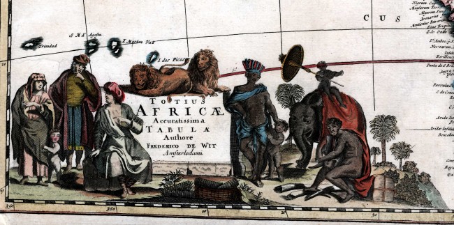
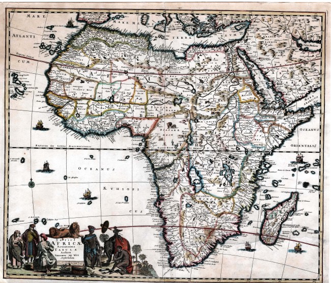

History & other information: The title of this map by the famous Frederic de Wit (1629 - 1706) is set within a strikingly attractive and coloured cartouche, which is representative of the seventeenth style of Dutch cartographers. De Wit was arguably the foremost map maker and publisher in the late seventeenth century in the Netherlands. His maps are in high demand.
The copperplate from which this map was printed underwent six changes during its publication history. This example is the less common first state: (the longitude axis begins 350 ... 360 ... 10; Amsterlodami in title). The map was printed before de Wit was granted a privilege (copyright) from Holland and West Friesland: according to Richard Betz, this first state of the map was prepared ca. 1670, and not 1680 as indicated by Tooley and Norwich.
The geography of this map was taken from earlier maps by him and his contemporaries. The interior was then unknown to European and consequently has ‘elephants for want of towns’ (and other animals). The coastline has typically exaggerated bays, but the southern Africa coastline is less pointed than many maps of the time. It does not reflect the settlement by the Dutch at the Cape of Good Hope. As dominance in map-making was transferring to the French, De Wit has taken an unwanted French creation, the phantom island of N.I. de sta. Helena (New St. Helena). However, he excludes the fantom islands to the south-east of Madagascar that were a fetur of earlier maps published in the Netherlands. This map was very popular and consequently was published at least six times over four decades. The map, and even the attractive cartouche, was copied by other Dutch publishers. The last printing of the map was by Pierre Mortier who bought De Wit’s plates in 1710 from widow de Wit.
Condition: This example of the map has been exceptionally well restored to leave a very attractive map in good condition. It has been cleaned, de-acidified and the page strengthened with acid free Japanese tissue. There is some age toning at the top left. Two very small areas of paper loss have been filled with no loss of integrity of the map but loss of R on CONGO REG and Ba in Bamba. Two tiny worm holes have been filled within the neatline and two outside the neatline. A number of small tears have been repaired with no loss. The page was closely trimmed at the bottom right but the neatline is intact.
References: Betz # 114; Tooley p. 123; Norwich #48.
Summary This well restored map is an extremely attractive map of Africa; it is almost 350 years old and was produced by a foremost Dutch cartographer.
- Overall Condition: Good - professionally restored
- Size: 57.0cm x 48.5cm
- Sold By: Thorolds Legal & Antiquarian Booksellers
- Contact Person: Kim Roberts
- Country: South Africa
- Email: [email protected]
- Telephone: 0118759991
- Preferred Payment Methods: Cash; EFT; Credit Card
- Trade Associations: Antiquarian Bookseller's Association


