


(20), 230 (i) pages, 2 folding maps, 1 single page map, 17 other maps in the text, good typography with decorative historiated initials, printer's mark on the title page, full contemporary vellum, light water staining at the bottom of the pages not affecting the printed area, some notations in an old had in ink in the margins, overall the contents are crisp and bright, a remarkable good copy.
'First edition with Munster's commentaries and woodcut maps. This work represents the non-Ptolemaic, non-scientific tradition of geography that dominated the Middle Ages. Solinus and Mela specialised in depicting the inhabitants of unknown lands as grotesque creatures. The most important legends are no doubt those which stimulated the early European exploration of Asia, Africa and America. A number of early expeditions beyond the confines of medieval Europe were at least in part motivated by attempts to confirm or disprove various legends. The most persistent of these concerned a mighty Christian king, Prester John who was thought to rule over the benighted masses, first of southern Asia and later somewhere in eastern Africa.
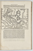
'The map of Asia in this volume holds great American interest. The northern corner of the map shows a strip of land called Terra Incognita: this represents one of the earliest renderings of America on a non-Ptolemaic map. The apparent strait between Asia and America anticipates Bering's voyage by two hundred years. In the text opposite the folding map (page 150), there is a short paragraph which refers to this piece of coast. One sentence states: 'In our days is has been explored by man.' (translated from the Latin). Wagner (Cartography of the Northwest Coast of America) observes that 'this remark has been noted by several writers who seem to think that it refers to some otherwise unknown expedition from Asia to the northwest coast of America....'
'The book also included a map of the river system of Russia represented with tolerable accuracy for the first time.' (Richard B. Arkway Inc. circa 1980)
- Overall Condition: Very Good
- Size: Folio (310 x 200 mm)


