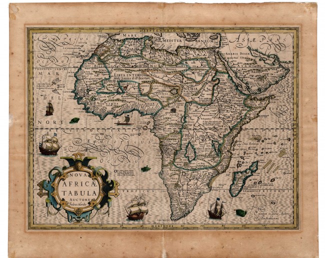

This famous map was published in the Gerardi Mercatoris Atlas (i.e. Atlas sive Cosmographicae Meditationes ...).
Prime meridian: Azores
Verso: recto (i.e. on the back of the right page of of two joined pages) p. 313 French text; signature Xxxxxx)
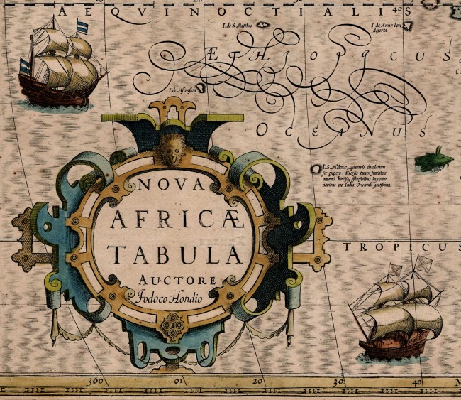
History & other information: This attractive map was drawn and beautifully engraved by the famous Flemish cartographer and engraver, Jodocus Hondius I (1563 – 1612). He added this map to the Gerardi Mercatoris Atlas, which he re-issued in 1606 after Mercator’s death and both he and his successor continued to publish it until 1630. The copperplate was unaltered throughout its publication, although the atlas was published ten times, six in Latin and four in French (this example of the map is from the first French edition).
The map depicts geographical changes based on information from Portuguese, Italian and Dutch sources. For example, Lake Sachaf in the south supplies only the unnamed Cuama River, and not Zaire or Nile Rivers; the shape of Madagascar is considerably altered from earlier maps. However, in the North, Hondius retained the eastward flowing Nubia Fluvius - was this the Yellow Nile? As was common at the time, Hondius includes two phantom islands to the south-east of Madagascar: I. De Juan de Lisboa and I. De los Romeros. He also shows Mt. Amara on the equator, below an annotation on the two sons of Prester John being kept captive on the mountain. The legend adjacent to St. Helena relates to fresh fruit, which reminds us that the ‘sea scurvy, caused the death of many European sailors on long voyages to and from the east.
Condition: It is in good condition even if the colours are not as rich some might prefer. There is some age toning and matt-caused discolouration outside the plate line and mild foxing. There are three short lengths of framer’s tape on the verso outside the plate line. There has been professional restoration of some short tears and three small patches of paper loss at the edges of the page – on the verso and outside the plate line.
References: Betz # 53; Tooley p. 54; Norwich #27; Jodocus Hondius: https://en.wikipedia.org/wiki/Jodocus_Hondius
Summary: This nicely coloured transitional map of Africa was produced by one of the finest map engravers on copperplate. We recommend some simple measures to enhance the maps conservation.
- Overall Condition: Good
- Size: 50.0cm x 37.5cm
- Sold By: Thorolds Legal & Antiquarian Booksellers
- Contact Person: Kim Roberts
- Country: South Africa
- Email: [email protected]
- Telephone: 0118759991
- Preferred Payment Methods: Cash; EFT; Credit Card
- Trade Associations: Antiquarian Bookseller's Association


