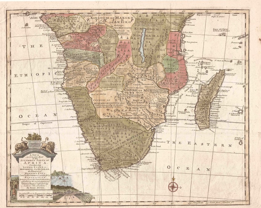
This attractive map by Emanuel Bowen is famous for its annotations more than its geography. Bowen usually followed the knowledge of the time; however, this map of southern Africa seems to be based on the geography of the famous French cartographer, Guillaume Delisle (1708). Nevertheless, Bowen's map colourfully depicts the Kingdoms and Empires of Africa, as they were known to the Europeans ... or thought to exist at the time .
The map includes all of Madagascar; while Bowen aspired to accuracy, the map also includes the mythical island of St. John of Lisbon (AKA Juan de Lisboa), to the south-east of Madagascar. This phantom island appeared commonly on maps of the 17th and 18th century.
Bowen's maps are also well known for their long titles, for being attractive and for his inclusion of interesting annotations. This map does not disappoint: it has along title and is attractive. In respect of annotations, the following are notable: 'Hancumquas: This nation is said to make use of Lions in fighting' or 'Cabonas: Antropophages or Men Eaters' or 'The Jagas: Antropophages or Men Eaters who have depopulated this Country, the Soil is very fertile, but the Air is esteem'd unhealthy' (in the 18th century, the miasma theory of disease held that bad air caused diseases such as malaria).
As to toponyms, Bowen misspells a number of place names; in today’s South Africa, these include 'Nossel Bay' for Mossel Bay; ('Hermosa By' for Formosa (Plettenberg) Bay), and ('Hellenbok' for Stellenbosch.
An attractive vignette at the bottom left includes an impressive cartouche. About the cartouche is a vignette with an inaccurate prospect of Cape Town and an illustration of Vergelegen, which had been Willem Adriaan van der Stel's country residence. The latter drawing was copied from the Kort Deductie (ca. 1708) in which Van der Stel published on his return to the Netherlands in an attempt to refute the burghers' claims against him that had resulted in his recall.
The halves of the map were printed on separate pages and have been joined. The map is in fine condition.
Emmanuel Bowen (c. 1693 – 1767) was a leading and prolific 18th century English cartographer who could engrave; he also sold maps & prints from his shop in London.
This is an attractive map and popular from the leading 18th century English cartographer; in addition, it has numerous conversation-generating annotations and topyonyms; it also depicts a short-lived phantom island in the Eastern (i.e. Indian) Ocean.
References:
Tooley's Maps of the African Continent and Southern Africa p. 32 & pl. 2.
Norwich's Maps of Africa #170
- Overall Condition: Fine
- Size: 43cm x 35 cm
- Sold By: Roger Stewart Antiquarian
- Contact Person: Dr. Roger Stewart
- Country: South Africa
- Email: [email protected]
- Telephone: +27836541081
- Preferred Payment Methods: LOCAL: EFT; INTERNATIONAL: Bank Transfer; Visa and Mastercard via PayFast
- Trade Associations: IMCOS


