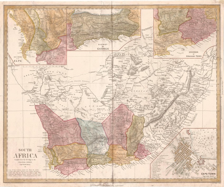
This is an attractively hand-coloured 1853 edition of the landmark 1834 map of South Africa that was produced from the latest information available to the Colonial Office in London.
This map first was published by the Society for the Diffusion of Useful Knowledge (SDUK) - after the Society's failure, George Cox acquired the plates from the SDUK printed the maps in 1853 and then sold the plates to Edward Stanford - this is an uncommon edition of the map . The Society's 1834 map appeared six weeks after the map by John Arrowsmith : "Both fulfilled a long-felt need for a reliable map of the country and have long been lauded by historians as the best maps of South Africa which were published at a time when the demography of the subcontinent was about to undergo a significant change." "The map indicates that it was Compiled from M.S. maps in the Colonial Office, as well as from information furnished by Captain Owen's Surveys” Like all contemporary small-scale maps of newly discovered areas of the British Empire, both maps were compilation maps put together by using various sources of information." (see Prof. Elri Liebenberg).
The map was considered to be 'state of the art' - it was included in Steedman's 1835 publication of Wanderings and Adventures in the Interior of Southern Africa. The map includes the magisterial districts of Swellendam, Beaufort, Cape Town, Stellenbosch, Albany, Worcester and George.
What sets this map apart from Arrowsmith's larger map, is the inclusion of four insets: the environs of Cape Town; George and Graham's Town; and a plan of central Cape Town. The "Society for the Diffusion of Useful Knowledge" was founded in 1826, manly at the instigation of Lord Henry Peter Brougham. The goal of the Society was to distribute useful information via a series of publications to the English working and middle classes. Its maps were published in an Atlas by Chapman and Hall. This edition of the map was published unaltered, by Cox and then and later by Edward Stanford - it was printed on firm paper by lithography and, unusually, is beautifully hand-coloured. These later ditions of the map are uncommon.
This landmark map is printed on firm paper and has been hand-coloured; it is in fine condition and will frame beautifully! SDUK London 1834
- Overall Condition: Fine
- Size: 44.6cm x 33.0cm
- Sold By: Roger Stewart Antiquarian
- Contact Person: Dr. Roger Stewart
- Country: South Africa
- Email: [email protected]
- Telephone: +27836541081
- Preferred Payment Methods: LOCAL: EFT; INTERNATIONAL: Bank Transfer; Visa and Mastercard via PayFast
- Trade Associations: IMCOS

Similar lots in the current auction View all
Click on an item to view more details and to bid.
.jpg)