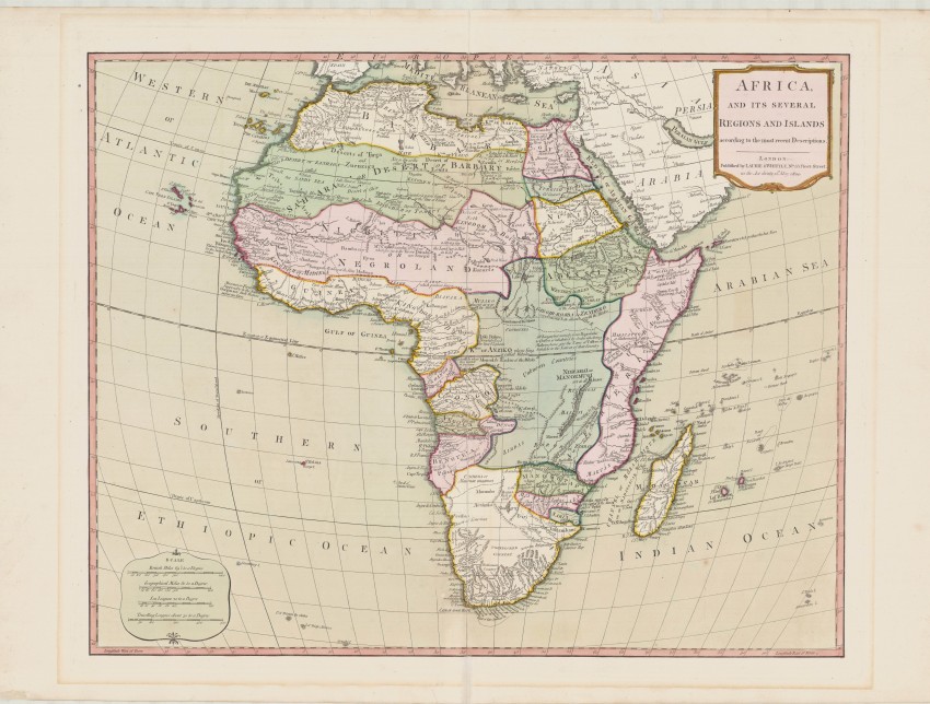
This very uncommon map wonderfully depicts in original full colour the partitioning of Africa by colonials and the indigenous peoples as understood in Europe at the end of the 18th century.
This map was sold unbound and, therefore, is now uncommonly available; the Antique Map Price Record has documented only three maps sold in the past 30 years. This map is not to be confused with a smaller map Africa and its several regions by Samuel Dunn, Mathematician, which was published in 1787 by Sayer and in 1794 by Laurie & Whittle for Dunn's New Atlas or Mundane System of Geography.
This map by Laurie and Whittle is a new engraving, published first in 1794 and again in 1800. The prime meridian is Ferro Island in the Canaries (Greenwich had not yet been established as the universal prime meridian). The map reflects 'unknown countries' in central Africa and notes that the northern limit of Lake Maravi (now Malawi) was 'not all known'; nevertheless, the great rivers are inaccurately placed and the Nile originates in two adjacent (Ptolemaic) lakes in Central Africa (it was known at that time that the Blue Nile originated in Ethiopia). Nevertheless, the map has a multitude of historically interesting annotations, e.g. “All of Zanguebar … is inhabited by Arabs who being Mahometans give the name of Caffres or Infidels to the Natives of that Country”. The annotations and the partitions are the most interesting features of this colourful map.
Recently the Laurie & Whittle map has assumed new importance in historical geography. It been selected for geo-referencing by the Stanford University Geospatial Center using a Bonne projection (Stanford conserves the famous Norwich Collection): “all map collar and inset information is also available as part of the raster image, including any inset maps, profiles, statistical tables, directories, text, illustrations, or other information associated with the principal map. As this map has been georeferenced, it also can be used as a background layer in conjunction with other GIS data.”
Robert Laurie (1755-1836) & James Whittle (?-1818): Laurie was a skilled mezzotint engraver, who worked with Robert Sayer on numerous projects. Whittle sold prints from his shop in Fleet Street shop. Laurie & Whittle joined forces and adopted their own imprint after Sayer's death in 1794. After Robert Laurie retired, his son, Richard (1777 - 1858) joined Laurie and the firm traded as "Whittle and Laurie". After Whittle’s death in 1818 the firm continued under the imprint of "R. H. Laurie" and, after R. H. Laurie's, Alexander Findlay took over the firm. It is now Imray, Laurie, Norie and Wilson Ltd – the oldest chart publisher in Europe. A genuinely uncommon map that wonderfully displays in full original colour the partitioning of Africa before the scramble really got going.
This beautiful and historically important map is in fine condition.
References: Norwich's Maps of Africa, map #118; https://geo.nyu.edu/catalog/stanford-cw053qy7632
- Overall Condition: Fine
- Size: 46 x 57 cm
- Sold By: Roger Stewart Antiquarian
- Contact Person: Dr. Roger Stewart
- Country: South Africa
- Email: [email protected]
- Telephone: +27836541081
- Preferred Payment Methods: LOCAL: EFT; INTERNATIONAL: Bank Transfer; Visa and Mastercard via PayFast
- Trade Associations: IMCOS


