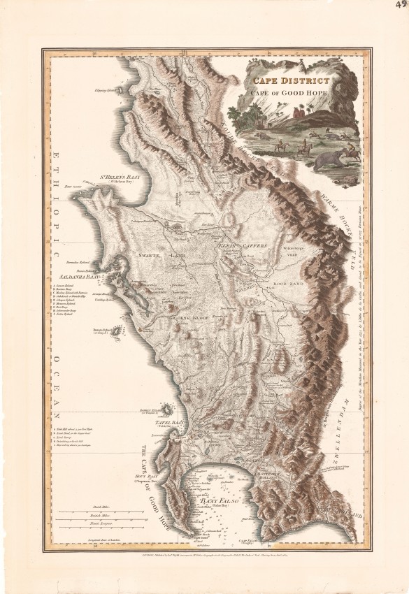
Delarochette compiled his map in 1782 from a number of primary sources, some up-to-date and some that were almost a century old. This first edition of the map was published as the Dutch Colony of the Cape of Good Hope and was published by William Faden. The map met the English need for a more accurate map of the territory in which it had become increasingly interested. Some changes were made to the copperplate in 1795 when the English took over the colony from the Dutch.
This map is fascinating because it is a cartographic version of an historical novel. The map includes some of the places visited by Simon van der Stel’s party in its journey into Namaqualand a century earlier. It features the names of some of the first settlers in the area between Table Bay and the Hottentots Holland Mountains (ca. 1675 – 1705). It shows the network of wagon roads in the colony in the 18th century; the routes of a number of these roads are still followed by modern arterial roads. Saldanha Bay and the coastline to St. Helena Bay were copied from De la Caille and famous French Hydrographer d’Après de Mannevillette ... and is not accurate.
It also names places that were prominent in the first scientific land survey, undertaken in 1752 by the French astronomer, Nicolas Louis De la Caille; e.g. Vygekaraal, Contreberg near today’s Darling and the mountain, Riebeeks Kasteel; De la Rochete also shows de la Caille’s terrestrial meridian and, along the right axis, gives its length, across a degree of latitude – an unusual record.
In August 1795 the English captured the colony after the Battle of Muizenberg and, in the same year, a new edition of the map was published with numerous name changes but with the title unchanged. On some copies of this 1795 new edition the route marched by the victorious military force was drawn in red by hand – on this example the route is engraved but not coloured.
The map was published again, unaltered, in 1825 and 1838 by James Wyld, and then by his son, the new owners of the publishing business. The only change to the map in 1825 & 1838 was the title. A German edition of this popular map was published by Schrämbl in 1789.
This map has been sensitively hand-coloured. It has been backed on to Japanese tissue paper to stabilises the edges outside the plateline. The map is magnificent when framed.
References:
Tooley's Collectors guide to Maps of Africa pp. 40 - 41;
Norwich's Maps of Africa, map#225
R Stewart De la Rochette’s map of the Cape of Good Hope. IMCoS Journal 2013; 132: 22 – 27Wm Faden London 1795
- Overall Condition: Very good
- Size: 32.5cm x 50.0cm
- Sold By: Roger Stewart Antiquarian
- Contact Person: Dr. Roger Stewart
- Country: South Africa
- Email: [email protected]
- Telephone: +27836541081
- Preferred Payment Methods: LOCAL: EFT; INTERNATIONAL: Bank Transfer; Visa and Mastercard via PayFast
- Trade Associations: IMCOS

Similar lots in the current auction View all
Click on an item to view more details and to bid.