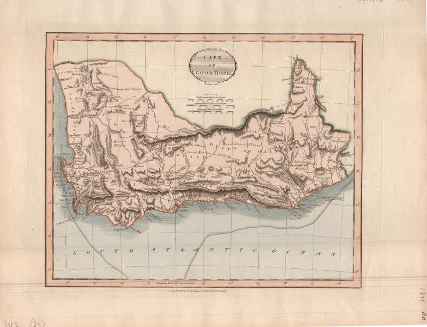
This is a beautiful and historically important map of the Cape Colony (the map is in original colour). Engraved on copperplate in 1816, the map was published in the 1819 edition of John Cary’s New Universal Atlas (which was published in seven editions between 1808 and 1844).
Cary (1754 - 1835) was an excellent engraver who established his own business in London as a Land Surveyor and publisher. He dispensed with decorative elements on his maps and focused, instead, on geographical accuracy.
This map shows the shift of the north-east corner of the Cape Colony to the Orange River, from Van Plettenberg’s Beacon ('Edelheers' on the map) - fragments of the beacon that survived destruction by the local San are arguably the oldest relic of San resistance to colonial expansion: it is conserved at the Iziko Museum as the Seekoei River Beacon.
Another interesting historical feature of the map is the record of the sinking of the Doddington (AKA Dodington), an East Indiaman that was wrecked in 1755 (not 1777 as on the map). The ship struck the eponymous rocks, a short distance from Bird Island off today’s Port Elizabeth, in Algoa Bay. Only 23 of the 250 crew and passengers survived, eking out an existence on fish, birds and eggs on the now-named Bird Island. They left the island after a few months, sailing to Delagoa Bay in a sloop constructed from the wreck's timbers - by one of the castaways, a carpenter. Controversial looting of the wreck’s silver and gold coins ("Clive of India's Gold") in the 1970s resulted in international legal battles and played a role in the establishment of UNESCO Convention on the Protection of the Underwater Cultural Heritage.
The map also depicts the route of John Barrow’s extensive travels in the Colony at the end of the 18th century. The old Lead Mine, near today’s Maitland River Mouth, is an uncommon feature that is shown only on the maps of Cary, Barrow and William Burchell.
This map is in original colour and in fine condition.
Reference: Tooley's Collectors' Guide to maps of Africa ... p. 35
- Overall Condition: Fine
- Size: 28.5 x 23 cm
- Sold By: Roger Stewart Antiquarian
- Contact Person: Dr. Roger Stewart
- Country: South Africa
- Email: [email protected]
- Telephone: +27836541081
- Preferred Payment Methods: LOCAL: EFT; INTERNATIONAL: Bank Transfer; Visa and Mastercard via PayFast
- Trade Associations: IMCOS


