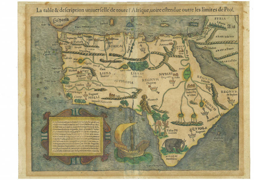
This is the 1556 French edition of the first map of the entire continent Africa that was and is still readily available.
The map was printed on two pages from a woodblock, the cutter of which is not known. Münster’s iconic map was printed uncoloured but many examples are now coloured, as is this one. This example of the map is from the 1556 French edition of the Cosmographia. This edition was published by Münster’s son-in-law, Heinrich Petri, soon after Münster died of the bubonic plague in 1552.
The map illustrated Sebastian Münster’s famous Geographia (1542, 1545 & 1552) and many editions of his Cosomographia (29 editions between 1544 and 1578). These are considered the beginning of modern Geography, although they described and illustrated the understanding of early geographers such as Claudius Ptolemy (a Greek who had lived in Alexandria under Roman rule and died in c. 170).
The map is famous for its depiction of the Cyclops (the tribe of Monoculi); parrots and an elephant. Kingdoms of indigenous inhabitants are represented by crowns and sceptres. The Kingdom of Prester John, the mythical, benign, Christian King, is represented by Hamarich, its supposed capital.
The map reveals a crack in the woodblock (identified as thin lines without ink). A vertical crack appeared in the woodblock from Sardinia in 1544, in the first edition of the Cosmographia; in 1552, the crack extended through Sardinia (therefore, present on this 1556 example).
The paper has age toning surrounding the map, caused by non-archival framing materials. Two small marginal tears that do not affect the map have been professionally repaired. Later colouring.
Reference: Richard Betz. Mapping of Africa. Map #3
- Overall Condition: Good
- Size: 34.3 x 25.7cm
- Sold By: Roger Stewart Antiquarian
- Contact Person: Dr. Roger Stewart
- Country: South Africa
- Email: [email protected]
- Telephone: +27836541081
- Preferred Payment Methods: LOCAL: EFT; INTERNATIONAL: Bank Transfer; Visa and Mastercard via PayFast
- Trade Associations: IMCOS


