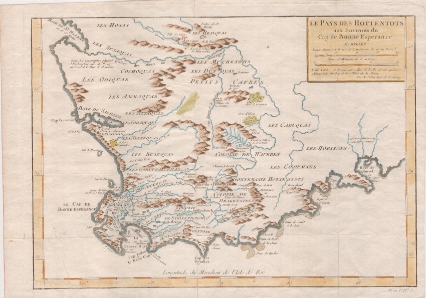
This French map, by a famous cartographer & hydrographer, is well known for its title that assigns the territory to the 'Hottentots'; it reflects European understanding of the location of various indigenous groups that lived in the south-western tip of Africa.
When this map was engraved there were few European settlers beyond the Hottentots Holland Mountains but the trekboere (migrant farmers) were on the move towards the region of the Baye de Mussel (Mossel Bay). Further eastward expansion near the coast was impaired for some time by the deep ravines east of the today's town of George.
Saldanha Bay is grossly distorted as is the annotation of a French Fort at the Bay - it was a pole with a flag that the local Dutch promptly took down.
In the subtitle, Bellin acknowledges his reliance on the map of Peter Kolbe - whose map, in the posthumous Dutch edition of his book, was a copy of the map by François Valentyn (see lot 188).
Jacques Bellin was an important maker of charts for the French Dépôt de la Marine. He was educated as an engineer and, as hydrographer at the Dépôt, he produced many important charts. His largest and most comprehensive and popular work was the Petit Atlas Maritime, with 581 charts that cover the coasts and important port cities of the known world.
Bellin's maps, such as this one, were also included in the Prévost d' Exile's monumental and very popular Histoire Géneral des Voyages. This map is the 5th map from Volume V of the Histoire (see bottom right outside the neatline: Tom V, No. 5)
This hand-coloured example of the map is in very good condition.
Reference: Tooley's Collectors Guide to Maps of Africa .... p 22
- Overall Condition: Very good
- Size: 34.4cm x 24.5cm
- Sold By: Roger Stewart Antiquarian
- Contact Person: Dr. Roger Stewart
- Country: South Africa
- Email: [email protected]
- Telephone: +27836541081
- Preferred Payment Methods: LOCAL: EFT; INTERNATIONAL: Bank Transfer; Visa and Mastercard via PayFast
- Trade Associations: IMCOS


