


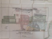
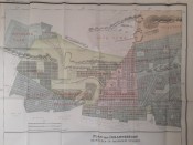
Sheet 1 of Jeppe's 1898 map of the Transvaal has historically important plans of Johannesburg and Pretoria, their suburbs and surrounding land. This map is in pristine condition.
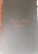
This sheet was sold separately, folded into a green cover. The map is a chromolithograph printed on glazed linen in Switzerland by Wurster, Randegger & Cie. The sheet was one of six sheets that comprised Jeppe's 1898 Map of the Transvaal or South African Republic and Surrounding Territories. Jeppe, who was chief draughtsman in the Surveyor-General's Office in Pretoria, compiled the 6-sheet map from official farm surveys and other information. Jeppe's map was so accurate and useful that during the Anglo-Boer War, the British attempted to have all copies destroyed - surviving copies were and still are much sought after!
The green cover has some minor scuffs and marks. This example of Jeppe's sheet with historic plans of Johannesburg and Pretoria is in fine condition. It is a beautiful item of cartographic Africana.
- Overall Condition: Fine
- Size: 68 x 77cm
- Sold By: Roger Stewart Antiquarian
- Contact Person: Dr. Roger Stewart
- Country: South Africa
- Email: [email protected]
- Telephone: +27836541081
- Preferred Payment Methods: LOCAL: EFT; INTERNATIONAL: Bank Transfer; Visa and Mastercard via PayFast
- Trade Associations: IMCOS


