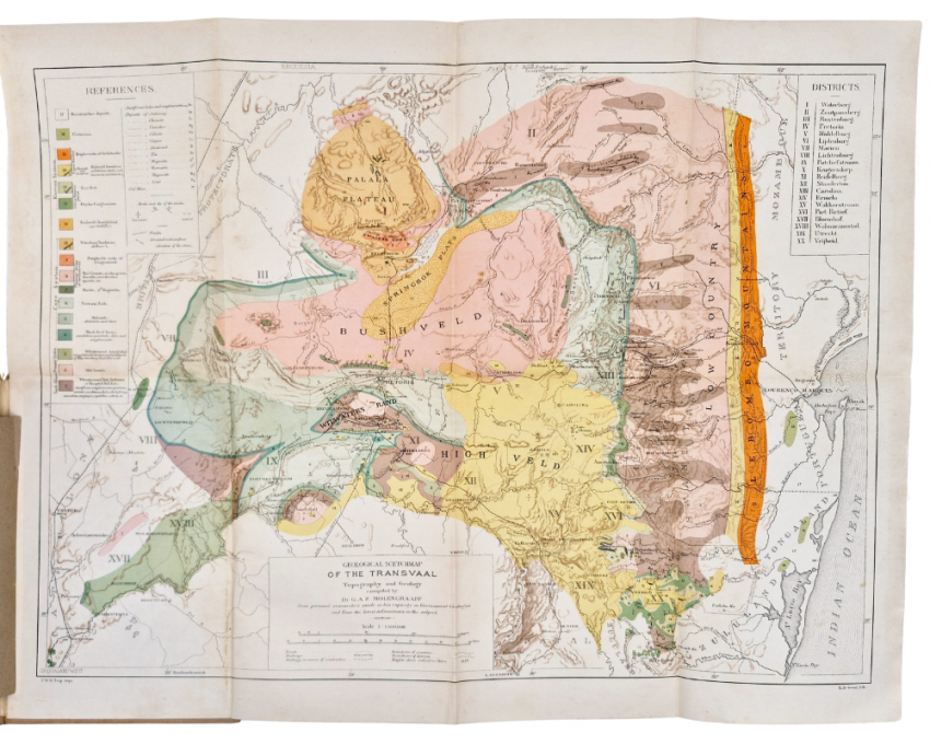
480 x 630 mm, coloured and printed in relief, mounted on linen, folds into decorated beige cloth covers, a very good copy.
Together with a booklet:
EXPLANATORY NOTE TO THE GEOLOGICAL SKETCH-MAP OF THE TRANSVAAL by Dr G.A.F. Molengraaff, 13 pages, 190 x 130 mm, green card wrappers, fitted into a pocket in the map cover.
(https://en.wikipedia.org/wiki/Gustaaf_Adolf_Frederik_Molengraaff): ‘Gustaaf Adolf Frederik Molengraaff (27 February 1860 in Nijmegen – 26 March 1942 in Wassenaar) was a Dutch geologist, biologist and explorer. He became an authority on the geology of South Africa and the Dutch East Indies. In 1897 Molengraaff became State Geologist of the Transvaal Republic. His task was to start the geological survey of the Transvaal. While mapping the Transvaal he discovered the Bushveld complex. In 1900 he got involved in the Second Boer War and had to return to the Netherlands. This gave him time to write a report on the geology of the Transvaal.’
See also: S2A3 Biographical Database of Southern African Science (https://www.s2a3.org.za/bio/Biograph_final.php?serial=1942) for an extensive biographical essay on Molengraaff from which the following is an extract: 'Meanwhile Molengraaff had been appointed to the new position of government geologist of the South African Republic in 1897. He assumed duty in September and soon became a citizen of the republic. His post included the directorship of the newly created Geological Survey and part of his brief was to collect rocks and minerals for its geological museum. Travelling in a specially equipped covered ox-wagon he made many excursions throughout the territory to familiarise himself with its geology before undertaking more detailed surveys. The work was reported in his annual reports for 1897 and 1898, but was interrupted by the outbreak of the Anglo-Boer War in October 1899. In his first report, which was published also in the Transactions of the Geological Society of South Africa (1898, Vol. 4(6), pp. 119-147), he gave a preliminary account of the succession of rocks in the southern half of the territory, including a review of earlier work by others. The next year he reported further on the stratigraphy of the territory, and in more detail on the geology of the districts Vryheid and Waterberg. These two reports were his most important contribution to South African geology. He summarised his findings in a comprehensive paper, "Geologie de la Republique Sud-Africaine du Transvaal" in the Bulletin de la Societe Geologique de France in 1901. An English translation, with some additions and corrections, was published in the form of a 90 page monograph, Geology of the Transvaal in 1904. He also published a Geological sketch map of the Transvaal. Topography and geology... (1:500 000, Johannesburg, 1902), with explanatory notes, and contributed a paper on "The glacial origin of the Dwyka Conglomerate" to the Transactions of the Geological Society of South Africa (1898, Vol. 4(5), pp. 103-115). He regarded the Witwatersrand Supergroup as part of a Primary System which included the basement granites; recognised the Ventersdorp Supergroup as a separate unit which he named the Vaal River System; was first to recognize and describe the Bushveld Complex as a geological unit which he named the Bushveld Plutonic Series; named the Waterberg Sandstone Formation (now the Waterberg Group), first recorded by H.S. Harger in 1898; and introduced the name Transvaal System for what he had previously called the Cape System, including the rocks of the Transvaal Sequence, the Bushveld Complex, and the Waterberg Group. He found that an extended period of folding and denudation preceded the deposition of the rocks of the Karoo Supergroup in the Transvaal, and accepted that the coal of the Transvaal and Natal was older than that of the Stormberg range in the Eastern Cape. He also concluded that the granite masses at Vredefort and between Pretoria and Johannesburg were older than the Bushveld granite and therefore probably not intrusive in the Witwatersrand Supergroup as he had originally thought. His book was the first to deal comprehensively with the geology of the territory.'
- Overall Condition: Very good
- Size: 480 x 630 mm